WABUBI CORRIDOR: CONNECTING ANIMAL HABITATS IN SOUTHERN PAPUA
By: Andhiani M. Kumalasari (Communication, Campaign, & Outreach Coordinator Papua Program)
Merauke - The expanse of forest in southern Papua invites curiosity to uncover the rich biodiversity within. Not just one, but three conservation area forests are home to a variety of unique flora and fauna. Wasur National Park (TN), Bupul Nature Reserve (CA) and Bian Wildlife Reserve (SM), all of which are located in Merauke Regency. Until now, the three conservation areas are still in good condition so that they are very supportive of the preservation of the various flora and fauna that live in them.
The potential wealth of biodiversity in the three regions can be analyzed through habitat quality. This analysis is carried out to see the extent to which these areas support the survival of flora and fauna in them. The existence of the three areas needs to be jointly managed properly, one of which is through the initiation of the formation of corridor zones.
Marthinus Wattimena as Acting Southern Papua Leader, WWF-Indonesia Papua Program explained, "the corridor concept functions as a link between conservation areas to see the relationship between one conservation area and another. This concept sees the area as an ecosystem or important habitat that must be interconnected and intact so that it can be managed sustainably. In addition, the connectivity of conservation areas is also established so that there is no ecological disconnection."
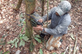
The establishment of this corridor concept begins with a study of the potential of the area. The Wasur-Bupul-Bian (WABUBI) corridor potential study activities began with field surveys at the village level using the camera trap installation method, biodiversity surveys, carbon potential surveys, focus group discussions (FGDs), and in-depth interviews involving the surrounding community.
In February-April 2016, WWF in collaboration with the Papua Natural Resources Conservation Center (BKSDA), Wasur National Park Center, and Musamus Merauke University conducted a spatial study to map the potential of ecosystem services in the study area connecting Wasur NP. Wasur and CA. Bupul, Merauke Regency, Papua. "The team surveyed the presence of animals using camera traps. Due to non-technical constraints, surveys in the Bian area could not be carried out so the focus of the study area became the area around Wasur and Bupul only. By using camera traps, we can reveal the presence of various species of animals without destroying their habitat," Marthinus explained.
There were 10 camera traps installed in the Wasur-Bupul corridor, precisely in five villages, namely Tanas (2 cameras), Bupul (2 cameras), Kweel (1 camera), Toray (3 cameras), and Erambu (2 cameras). Of the five villages surveyed, Erambu is an area with relatively excellent animal habitat conditions. But overall, the five survey locations still have good animal habitat conditions and forest cover in the area is still maintained. This is evidenced by the presence of many protected animals such as kangaroos, cassowaries, king cockatoos, mambruks, pigs, deer, maleos, and various other bird species. However, threats to species are triggered by the emergence of hunting using firearms and land allocation for cultivation activities.
From the results of the study, data on the corridor area was also obtained. The indicated area of the Wasur-Bupul corridor is 117,797 ha and the Bian-Bupul corridor is 100,175 ha. Based on this area, it can be identified that this area is dominated by areas with high habitat quality. The Wasur-Bupul corridor includes the customary areas of Bupul, Tanas, Kweel, Toray, and Erambu villages while the Bian-Bupul corridor includes the customary area of Kaiza village.
Furthermore, the results of ecological, economic, social, and cultural studies in the Wasur-Bupul corridor for the WABUBI Corridor Area have been disseminated through workshop activities held on September 21-22, 2016. On the same occasion, WWF together with the Wasur National Park Center, the Papua Natural Resources Conservation Center (BBKSDA), and the KSDA Section of Region I carried out the initiation of the Wasur-Bupul-Bian (WABUBI) corridor as a link between the conservation areas of Wasur NP. Wasur, CA. Bupul and SM. Bian.
Regarding the establishment of corridors, the community strongly supports the initiation of corridor formation as a model of sustainable area management for biodiversity, local wisdom, and the local economy. The community provides a view that there needs to be economic alternatives for the short, medium and long term. In the short term, people can get economic benefits from the forest for a few days (hunting and gathering). For the medium term, the community can raise livestock, grow crops, gardening (rambutan and candlenut), and fisheries. As for the long term, people can earn income through rubber plantations, agarwood, gambier, and ecotourism to observe wildlife such as birds of paradise.
The Merauke Regency Government strongly supports the results of this study. This study is related to the inclusion of Merauke Regency in the low carbon economy strategic area scheme in Papua Province and the implementation of low carbon development where the WABUBI location is a priority location including the results of the Strategic Environmental Assessment (KLHS) recommendations.
Regulatively, the corridor area can also be included in the FMU (Forest Management Unit) formation scheme in the form of conservation, protection, and cultivation functions that are adjusted to the results of the parties' discussions. With the initiation of FMU formation, it is expected that there will be an institution that manages the area properly and across sectors. Institutions for corridors can use several approaches, namely Conservation FMU (KPHK), Protection FMU (KPHL), and Production FMU (KPHP), and even through a rural area approach.